Hello,
I am trying to find the names of the settlers who cleared the fields and built the barns in what is now Burgoyne Bay Provincial Park. This information may be available on the Historical Society's web-site, but I was unable to find a way to start searching for it, no doubt due to my less than stellar computer skills.
I would be grateful for any names you could give me, or a direction to begin looking.
Also, I am interested in the Native Cowichan place-names for areas of south Salt Spring, around the Burgoyne Bay Park and Mt. Maxwell. Is there an on-line list of these names? I have tried contacting the Band Office in Duncan, and they said they would get back to me, but haven't done so.
Sincerely,
Rosamonde Dupuy.
Burgoyne Bay was Originally pre-emted by John Maxwell and his partner James Lunney
http://saltspringarchives.com/bmcwirter/bmcwirter/Maxwell_Trage/pages/1JohnMaxwell.htm
The Cowichan placenames are at:
http://saltspringarchives.com/multicultural/firstnations/map.html
I will be working on the pronunciation of these names soon.
Greetings hist' ry buffs, Maxwell was preceded by James Shaw in 1859 but he was made unwelcome by First Nation owners and forced to leave ..along with others ..Maxwell married Cowichan woman, Mary, from Clemclemaluts and was permitted to stay. Maxwells cleared most of the land using industrial machinery (first of its kind inBC) beginning with gusto in the 1880's...for ranching and mixed farming. He built the farmhouse (used as post office)..Present day buildings (with the exception of Richard Maxwell's house, and outbuildings at park entrance) were built by the Larson Family from the US who purchased the entire Maxwell holdings in 1940's..tore down old Maxwell barns (at least two) and original farmhouse by the bay...., felled the orchards, built concrete flume on Fulford Creek and focused on dairy and beef ...More detailis in my manuscript Cultural and Historical values of the Burgoyne Valley (or something to that effect) which I prepared for Friends of Salt Spring Island Parks for BC Parks which should be archived somewhere.
Hello Frank N.,
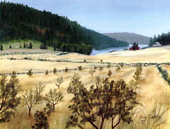
Thanks for the info . I have checked out the two sites you sent. I am very interested in the history of the Burgoyne Bay, as I spend a lot of time there painting & sketching.
I am working on a series of large oils, which I call "Xwaaqw'um". Briony Penn gave me this name, as the Cowichan name for the Burgoyne Bay, meaning, "Place of the Mergansers "(or Sawbills). I am glad to see it is the same on the site you sent. I have been using (for my paintings) the name "Hwmatet'sum" for Mt. Maxwell, which is spelled differently on the map you sent.There are other names close by, "Shwuxwus'ule'a" and "Q'iq'uwutum", which I would like to know more exactly where they apply, as it is hard to tell from the map.
(My paintings, by the way, are not photographic depictions of the place, as paintings of that sort hold no interest for me...better just to take photos, I think.)
Looking through the names of Salt Spring Island roads, I noticed that there is no info on Sharp Road. My parents bought a place there in 1972, which used to be part of Mrs, Murakami's family place (Eto). I know that the road was named after a Mr. Sharp, who lived on the property my parents bought. Later(?), there was a Mr. Wakelin, who died there. Of course, the land was expropriated during the war. It's too bad that road isn't called Eto Road, or Murakami Road, or even Little Tokyo Road, as the small, very fertile valley there was known at the time. My parents' place is on the old portage route coming from Booth Bay, which went through to Ganges, so there is a lot of Native & Japanese history at that spot. My brother, Michael Hunt, lives there now, & would probably know more about the history, dates, and the name Sharp.
I was in touch with you some time ago about Lumley Road, which isn't mentioned on the list. Now , what's left of it (the bottom half has been privatised, and closed to the public), has become a walking trail, not possible to drive on, but it is still called Lumley Road. I have been trying to keep this name "on the books", as there is a neighbour who is busy trying to erase its memory. It is named after the Lumley family, Hawaiian settlers, part of the Harris family, on Mountain Road, & was a connecting road between what is now our place & the Hawaiian community at Isabella Point. I did get the Lions to put it back on the map in their phone book,so am happy about that.
Sincerely,
Rosamonde.
![]() |
![]() |
While we are looking for it (Chris should know where it is? - the author Chris Arnett), have you looked through the draft management plan for Burgoyne Bay Park?
http://www.llbc.leg.bc.ca/public/pubdocs/bcdocs/460989/burgoynepp_mp_draft.pdf
Usha
BINGO!
Chris Arnett's "Cultural and Historic Values of Hwaqwum – Burgoyne Bay, Salt Spring Island, BC." is featured as Appendix 1 in the "Burgoyne Bay Background Report" prepared for BC Parks, Salt Spring Island, BCMarch 31, 2003
It is an unpublished report also featuring writing by Briony Penn.
I have found a couple of quotations:
“Of Burgoyne Bay – the sheer physical beauty of the place is obvious – beneath the magnificence of Mount Maxwell an unpaved country road meanders through Douglas fir forest on one side, open fields on the other, to a sparkling bay where a tow-hold [sic] of industry flanks a sweeping bay fringed by forest. . . . The place is called Hwaaqwum (hwaw-kwum) “place of the sawbill duck” a name that described its most important resource. Saw-bill ducks were harvested by the hundreds (by First Nations) with large aerial nets during the summer and autumn months, speared, singed and dried for winter use. Herring was raked in the bay and sea-mammals hunted. The shoreline harboured rich clam beds and a stream with coho and chum salmon taken in summer and dried. Further inland were clearings of red-clover and camas fields, cedar groves and berry patches.” (C. Arnett, “PLACE – The Final Frontier”, unpublished document, 1999)
The land within and around Burgoyne Bay harbours historical and cultural values from thousands of years of human activity; although the area has had human impacts (e.g. land clearing for farming, log sorts on land and in the water), it has had relatively little modern development. The Burgoyne valley and bay retains an atmosphere embracing the cultural and spiritual values of local First Nations and the heritage of one of BC’s first inter-racial settler communities (Arnett, 2003).
Re my last post:
Chris Arnett's "Cultural and Historic Values of Hwaqwum Burgoyne Bay, Salt Spring Island, BC." is SAID TO HAVE BEEN featured as Appendix 1 in the "Burgoyne Bay Background Report" prepared for BC Parks, Salt Spring Island, BC
March 31, 2003
I have found the document quoted, and here is its Appendix 1 - I'm not sure it's what Chris wrote, as it is title d differently, as "Burgoyne Bay Park Public Consultation"
Usha
Appendix I:
Burgoyne Bay Provincial Park Public Consultation
Over the course of one public meeting, two open houses, one stakeholder meeting and input by
mail, e-mail and website, the public showed overall support for the proposed key values, issues,
and management directions identified for this park, with concern over balancing ecosystem
management and cultural sites with recreation use.
The public input for Burgoyne Bay is best summarized as diverse and passionate. The key topics
of submissions were:
• the level of agricultural practice appropriate for the park: maintaining and possibly increasing
of agricultural practices or stopping all agricultural practices for ecological reasons;
• the importance of the ecological health of the park and neighbouring bay and establishing
what recreation activities would be appropriate to maintain a healthy balance;
• maintaining the values of quiet, solitude and nature appreciation of the park and the bay by
limiting what recreation and agricultural activities took place there and what facilities were
developed (i.e. camping, parking, equestrian use, boat launch, etc.).
Agriculture
There was significant input from the agricultural community at both open houses and via web
comments. Their main interest is in the fact that Burgoyne Bay Park includes 2.6% of the
Agricultural Land Reserve land on Salt Spring, and, with the increasing movement towards
growing and buying local foods, they feel that these lands would best be used for direct
agricultural production. The Island Natural Growers has developed a farm management plan for
Salt Spring Island. They have offered to BC Park to prepare a farm management plan for
Burgoyne and Ruckle Provincial Parks. Other possibilities offered by agricultural supporters
were using the area for seed and plant sanctuary, for demonstrating organic farming, etc. No
specific proposal has been presented.
“It is significant that descendants of the original settlers still live in the area and that one
continues to hay the land. The land supported productive mixed farming” (Public,
personal communication, 2007).
Recreation Use
• Horse Back Riding - the equestrian community requested access for horseback riding in
Burgoyne Bay Provincial Park and up into the Mill Farm Reserve. They have also requested
proper trail maps in all of the parks be developed that identify where they can ride their
horses.
• Marine Facilities - boat launching, mooring, and docking were requested from the public for
Burgoyne Bay. However, many feel that it is important for the environmental sustainability
and health of the bay and shoreline area that boats not be permitted or limited to non-
motorized vessels only. BC Parks presently does not protect the foreshore area of Burgoyne
Bay.
One of many boat launch advocates stated:
“Boat launch for access to the ocean for non-motorized boats (canoe and kayak) would
provide much needed access on the west side of the island. Would like to see the bay
designated non-motorized to preserve the ecological sensitivity of the area for shore birds
and the eelgrass meadows and the quietness” (Public, personal communication, 2007).
• Other activities - A small lobby group was interested in areas in the park being developed as
playing fields and a disc golf course. (There were a significant number of individuals who
were against both these activities in the park).
Environmental Concerns
Almost all comments noted the importance of the natural environment of Burgoyne Bay
Provincial Park including the bay area and the need to balance activities with the health of the
natural environment. Many had concern over the continued success and protection of nesting
songbirds, wintering water birds, owls and raptors if human activities and facilities increased, or
current uses changed substantially (including the haying). For example:
“If protection is to be accomplished then the kinds of recreational activities to be allowed in
this park need to be considered extremely carefully” (Public, personal communication, 2007).
This also tied into the desire to maintain the quiet, peace, and beauty of the park by keeping
development of parking and camping to a minimum or not at all and out of the “visual
landscape” of those visiting the park. Recommendations for parking were to keep it at the current
quarry area at the end of the road and in the quarry area that is currently gated. Some asked that
nothing be done to the park at all. Others asked that all of the adjoining parks become a
Biosphere Reserve and that the highest protection possible be placed on this park.
One person in particular asked the question that covers most of the main environmental concerns:
“Species listed under Environment Canada’s Species at Risk Act as ‘at risk’,’ threatened’ or
of ‘special concern’, reside in the Burgoyne Bay Park including Long-toed salamanders,
Dusky-wing butterfly, Phantom orchids, Peregrine Falcon and Northern red-legged frog.
Does BC Parks intend to protect such species and their habitat and how do they intend to
accomplish such protection; fencing off such areas is a reasonable course of action that will
ensure success” (Public, personal communication, 2007).
Another brought up the following statement concerning the ecologic importance of the park and
its neighbouring park and reserves:
“[Burgoyne] links up with other protected areas creating the largest area of undeveloped
Coastal Douglas fir biogeoclimatic zone with all the related ecosystems. This is a threatened
environment containing so many species at risk and so many species that will soon be
threatened. This is clearly the biggest value of this park and related lands” (Public, personal
communication, 2007).
The key values, activities, and issues expressed through the public consultation process are listed below.
Key Values
• Significant in terms of richness of habitats and wildlife;
• Diversity of the habitats in a small area: threatened Garry oak and Douglas fir ecosystems
surrounding seral grasslands that are regularly hayed and yet provide important nesting
habitat for birds, riparian habitat, and salmon bearing streams;
• Important shoreline habitat and eelgrass beds;
• Species-at-risk present in park;
• Silence – natural noises only providing a unique opportunity for the quiet enjoyment of
nature that is hard to find on Salt Spring Island;
• Nature appreciation: bird watching, wildflower viewing, wildlife viewing in the bay;
• The farm buildings for historical reasons and shelter;
• The boulder fields and their link to First Nations;
• First Nations history.
Key Activities
• Hiking – in fields, along shoreline, link to Mount Maxwell summit;
• Horseback riding;
• Bird watching;
• Kayak/canoeing – but limited to single landing area and information signage to prevent
damage to the estuary;
• Agriculture – potential for anything from haying to organic farming/gardening in existing
fields;
• Continued haying of the fields to maintain seral grassland and reduce fire hazard and
invasive done with the timing of ground nesting birds taken into account;
• Day use activities only;
• Education i.e. an ecological learning centre (Educational groups on the environment
education programs including Gulf Island Center for Ecological Learning [GICEL])
• Walk in camping only – not near the shore, not in the fields, out of line of site.
Key Issues
• Viewed inappropriate recreation activities such as disc golf course, base ball diamond, soccer
fields, etc;
• Camping – concerns over potential for damage from heavy use and the need for more
infrastructure
• Agriculture use of the valley
• Off-leash dogs - dogs are a major problem in any park. It is not appropriate to allow them
free run at anytime, as the impact to wildlife, waterfowl, and sensitive plants;
• The need for more research to better understand the environmental nature of the park and
what levels of recreation activity would be appropriate for proper conservation and
protection;
• Maintaining and improving the water quality of the bay and the creeks flowing into it;
• Types of recreation and level of vehicle access;
• The need to gain foreshore rights as soon as possible;
• Fire control and the incendiary nature of the higher elevations of the park and assess the
potential of a major fire on the mountains from the activities of careless hikers;
• Lack of BC Parks personnel presence in the park and the island to enforce activities that are
not allowed and the need for a resident park warden on the island and in the park;
• Security and eating locally, especially on Agriculture Land Reserve lands in parks.
Chris Arnett's report is referenced in a web page that ought to be archived in the SSIA (it makes a great read):
http://www.crcresearch.org/case-studies/crc-case-studies/community-action-salt-spring-island
As for my hunt for the report itself, at present I have to move on, having Other Things to Do (HOT2Do?)
Chris is probably the best resource to resort to...
But once upon a time I did come across a wonderful archive of the history of Fulford, or something of that sort, by a group of people named something like Friends of Fulford, or of the Fulford Valley (sic...!!!???)
It's not popping back into view at present for me.
Usha
Indian legend has it that a ferocious sea monster called “Shuh-shu-cum” (Open Mouth) once lived at the tip of the point. He would lie with his snout out of the water and when anyone tried to pass close to the point he would open his mouth and suck in the canoe with its passengers. No one knew what to do about “Shuh-shu-cum” but one brave had heard of a man called “Sum-al-quatz” who lived on the mainland and was said to have the strength of a thousand men. The brave decided to seek out “Sum-al-quatz” to ask for his help so he paddled across to Burgoyne Bay and walked across Saltspring Island where he borrowed a canoe and paddled to the mainland.
“Sum-al-quatz” agreed to help. He loaded a boulder into his sling and “let it fly”. But his aim was off and the boulder landed in Ladysmith. His second shot landed near Mayne Island. The third landed in Maple Bay and is now known as Paddy’s Milestone. “Sum-al-quatz” explained that he couldn’t get a good aim as Mount Maxwell (or “Hwmat’etsum” - Bent Over Place) was in the way.
They called to the mountain’s spirit and asked him to hunch down so that “Sum-al-quatz” could get a better aim. Mount Maxwell lay down on his belly and hunched his shoulders.
Mount Maxwell from Burgoyne Bay - Photo courtesy Top Brass
The next boulder cleared Mount Maxwell and hit “Shuh-shu-cum” on the snout. That put an end to “Shuh-shu-cum’s” snout and his sucking up of the canoes but it did not destroy him. He still lives in the deep waters and whenever you see swirls and eddies near Octopus Point you know that he is nearby.
(Sources: Agnes Thorne “The Monster of Octopus Point” in When the Rains Came and Other Legends of the Salish People as told to Dolby Bevan Turner, Orca Book Publishers, Victoria 1992.
Peter Rusland “The Legend of Octopus Point” (interview with Simon Charlie) Cowichan News Leader November 15, 2000 p.3.
BC Geographic Names database)
http://www.mbyc.bc.ca/History/octopus_point.htm
(To avoid becoming "insular" I recommend this entire website - it is the view of the west side of our island from across the waters, from the east side of Vancouver Island)
Burgoyne Bay (48° 48' 00" N - 123° 32' 00" W) sits below Baynes Peak.
It was named in 1859 by Captain Richards after Commander Hugh Talbot Burgoyne VC who was an officer aboard HMS Ganges under the command of Captain Fulford. He was awarded the VC for gallant action during the Crimean War. According to the Canadian Geographical Names Database, he and most of the crew of 500 died when their ship “Captain” turned upside down and foundered off Cape Finisterre. A Post Office was once located at Burgoyne Bay from 1880 to 1900. In the 1990s, attempts by Texada Logging to harvest timber in Burgoyne Bay created quite an uproar on Saltspring. Now, the shores of Burgoyne are protected by the Mount Maxwell Ecological Reserve. It is 4 miles across Saltspring from Burgoyne to Fulford and the wind which often blows out of this bay has traveled across the island through the low-lying Fulford-Burgoyne Valley.
Mount Maxwell (48° 48' 00" N - 123° 31' 00" W) was named Baynes Mountain by Captain Richard in 1859 after Rear Admiral Baynes who was commander of the Pacific Fleet from 1857 to 1860 but local residents called it Mount Maxwell after John Maxwell who farmed in the area in the late 1800s. Mount Maxwell was adopted as the official name in 1911 “as an entrenched local name”. According to the BC Geographic Names database, through correspondence with authorities on Saltspring Island, agreement was reached in 1939 to call the highest point Baynes Peak and the mountain top park Mount Maxwell Park.
http://www.mbyc.bc.ca/History/LastGreatBattle.htm
(at Maple Bay: What we do know from historical sources is that Maple Bay was the site of a great battle when “the water became red with the blood of the slain”. Much more to read about it if you go to the URL page)
http://www.mbyc.bc.ca/History/from_maple_bay_village_to_imaden.htm
From Maple Bay Village to Imadene Cove
Maple Bay Village. Before the railway and the highway, Maple Bay and Cowichan Bay used to be the points of entry to the Cowichan Valley.
A steamer from Victoria called in every two weeks and landed at the site of the present government wharf. In the early 1860s, Tom Windsor built a store and an inn at the head of the wharf adjacent to what is now the current parking lot. The inn and store were later sold to William Beaumont who hoped to develop a town as this area had been surveyed for a townsite in 1864. His hopes were dashed with the arrival of the railway at Duncan’s Crossing.
While Maple Bay did not become the commercial centre for the Cowichan Valley it did become a community with some farms, some permanent residences, multitudes of summer cottages, a store - the Maple Bay Trading Company (now the Grapevine) and a hotel - the Maple Inn (now the Brig and Beaumont Place). The original inn built by Tom Windsor became a private residence and was known as the “Hattie House” until it was torn down sometime around 1960.
Maple Bay Beaches. Much has changed now with the proliferation of wharves along the shoreline but there used to be only 5 good stretches of shingle beach around the northwestern perimeter of the Bay and each had an informal name among bayside residents, usually the name of the adjacent property owner. The beach in front of what is now MBYC was called Wood’s beach. T.A. Wood first built a beach cottage and later a permanent home which is now the MBYC clubhouse. Duffy LeQuesne says she recently heard the next stretch of shingle to the north referred to as Elkington beach as this was where the beach cottage of William Elkington stood. The long stretch of sand below the bluff is known as Mackenzie beach as the Mackenzie’s had a fox farm here (presumably above the bluff). The longest and most used stretch of shingle fronts the village of Maple Bay.
The rocky point to the northeast of the Brig and Beaumont Place is known as Corfield Point after the Corfield residence that still stands there. Further to the east is the smallest beach, Peggy’s Cove (or Peggy’s Bay). This used to be a secluded little hideaway reached only by water or a steep trail through the trees. No one seems to know how Peggy’s Cove got its name.
Imadene Cove. This property south of MBYC was once the site of Camp Imadene, a Plymouth Brethren camp started in 1926 by Miss Lenore Rice in her father’s boathouse. As the camp grew, bunkhouse cabins were built around the periphery of the property while the main building and dining room stood close to the water. As the building extended out over the rocks, a beach walk from Maple Bay to Birds Eye frequently required a climb through the verandah supports. At high tide it was impassable though wandering kids were known to scurry across the verandah while the campers were occupied elsewhere. The camp owned a fleet of rowboats, all painted bright red so during recreation time the waters in front of the camp were dotted with a bright flotilla.
Indian legend has it that a ferocious sea monster called “Shuh-shu-cum” (Open Mouth) once lived at the tip of the point. He would lie with his snout out of the water and when anyone tried to pass close to the point he would open his mouth and suck in the canoe with its passengers. No one knew what to do about “Shuh-shu-cum” but one brave had heard of a man called “Sum-al-quatz” who lived on the mainland and was said to have the strength of a thousand men. The brave decided to seek out “Sum-al-quatz” to ask for his help so he paddled across to Burgoyne Bay and walked across Saltspring Island where he borrowed a canoe and paddled to the mainland.
“Sum-al-quatz” agreed to help. He loaded a boulder into his sling and “let it fly”. But his aim was off and the boulder landed in Ladysmith. His second shot landed near Mayne Island. The third landed in Maple Bay and is now known as Paddy’s Milestone. “Sum-al-quatz” explained that he couldn’t get a good aim as Mount Maxwell (or “Hwmat’etsum” - Bent Over Place) was in the way.
They called to the mountain’s spirit and asked him to hunch down so that “Sum-al-quatz” could get a better aim. Mount Maxwell lay down on his belly and hunched his shoulders.
The next boulder cleared Mount Maxwell and hit “Shuh-shu-cum” on the snout. That put an end to “Shuh-shu-cum’s” snout and his sucking up of the canoes but it did not destroy him. He still lives in the deep waters and whenever you see swirls and eddies near Octopus Point you know that he is nearby.
(Sources: Agnes Thorne “The Monster of Octopus Point” in When the Rains Came and Other Legends of the Salish People as told to Dolby Bevan Turner, Orca Book Publishers, Victoria 1992.
Peter Rusland “The Legend of Octopus Point” (interview with Simon Charlie) Cowichan News Leader November 15, 2000 p.3.
BC Geographic Names database)
http://www.mbyc.bc.ca/History/octopus_point.htm
(To avoid becoming "insular" I recommend this entire website - it is the view of the west side of our island from across the waters, from the east side of Vancouver Island)
Burgoyne Bay (48° 48' 00" N - 123° 32' 00" W) sits below Baynes Peak. It was named in 1859 by Captain Richards after Commander Hugh Talbot Burgoyne VC who was an officer aboard HMS Ganges under the command of Captain Fulford. He was awarded the VC for gallant action during the Crimean War. According to the Canadian Geographical Names Database, he and most of the crew of 500 died when their ship “Captain” turned upside down and foundered off Cape Finisterre. A Post Office was once located at Burgoyne Bay from 1880 to 1900. In the 1990s, attempts by Texada Logging to harvest timber in Burgoyne Bay created quite an uproar on Saltspring. Now, the shores of Burgoyne are protected by the Mount Maxwell Ecological Reserve. It is 4 miles across Saltspring from Burgoyne to Fulford and the wind which often blows out of this bay has traveled across the island through the low-lying Fulford-Burgoyne Valley.
Mount Maxwell (48° 48' 00" N - 123° 31' 00" W) was named Baynes Mountain by Captain Richard in 1859 after Rear Admiral Baynes who was commander of the Pacific Fleet from 1857 to 1860 but local residents called it Mount Maxwell after John Maxwell who farmed in the area in the late 1800s. Mount Maxwell was adopted as the official name in 1911 “as an entrenched local name”. According to the BC Geographic Names database, through correspondence with authorities on Saltspring Island, agreement was reached in 1939 to call the highest point Baynes Peak and the mountain top park Mount Maxwell Park.
http://www.mbyc.bc.ca/History/LastGreatBattle.htm
(at Maple Bay: What we do know from historical sources is that Maple Bay was the site of a great battle when “the water became red with the blood of the slain”. Much more to read about it if you go to the URL page)
http://www.mbyc.bc.ca/History/from_maple_bay_village_to_imaden.htm
From Maple Bay Village to Imadene Cove
Maple Bay Village. Before the railway and the highway, Maple Bay and Cowichan Bay used to be the points of entry to the Cowichan Valley. A steamer from Victoria called in every two weeks and landed at the site of the present government wharf. In the early 1860s, Tom Windsor built a store and an inn at the head of the wharf adjacent to what is now the current parking lot. The inn and store were later sold to William Beaumont who hoped to develop a town as this area had been surveyed for a townsite in 1864. His hopes were dashed with the arrival of the railway at Duncan’s Crossing.
While Maple Bay did not become the commercial centre for the Cowichan Valley it did become a community with some farms, some permanent residences, multitudes of summer cottages, a store - the Maple Bay Trading Company (now the Grapevine) and a hotel - the Maple Inn (now the Brig and Beaumont Place). The original inn built by Tom Windsor became a private residence and was known as the “Hattie House” until it was torn down sometime around 1960.
Maple Bay Beaches. Much has changed now with the proliferation of wharves along the shoreline but there used to be only 5 good stretches of shingle beach around the northwestern perimeter of the Bay and each had an informal name among bayside residents, usually the name of the adjacent property owner. The beach in front of what is now MBYC was called Wood’s beach. T.A. Wood first built a beach cottage and later a permanent home which is now the MBYC clubhouse. Duffy LeQuesne says she recently heard the next stretch of shingle to the north referred to as Elkington beach as this was where the beach cottage of William Elkington stood. The long stretch of sand below the bluff is known as Mackenzie beach as the Mackenzie’s had a fox farm here (presumably above the bluff). The longest and most used stretch of shingle fronts the village of Maple Bay.
The rocky point to the northeast of the Brig and Beaumont Place is known as Corfield Point after the Corfield residence that still stands there. Further to the east is the smallest beach, Peggy’s Cove (or Peggy’s Bay). This used to be a secluded little hideaway reached only by water or a steep trail through the trees. No one seems to know how Peggy’s Cove got its name.
Imadene Cove. This property south of MBYC was once the site of Camp Imadene, a Plymouth Brethren camp started in 1926 by Miss Lenore Rice in her father’s boathouse. As the camp grew, bunkhouse cabins were built around the periphery of the property while the main building and dining room stood close to the water. As the building extended out over the rocks, a beach walk from Maple Bay to Birds Eye frequently required a climb through the verandah supports. At high tide it was impassable though wandering kids were known to scurry across the verandah while the campers were occupied elsewhere. The camp owned a fleet of rowboats, all painted bright red so during recreation time the waters in front of the camp were dotted with a bright flotilla.